 |
|
 |
| Mission | Search | Acknowledgements | Discussion Group | Contact Us | Links | ||
| ||||||
|
Maine DEP Monthly
Maine and WEF's
Penobscot Watershed and Development of a TMDL
Maine Rural Water
Maine
Wastewater Control Association |
The Georges Highland Path, marked throughout with blue paint blazes, begins at the trailhead parking area and follows for a short distance through the woods to Thomaston Mountain, a large hillock of earth created when the lagoons were excavated. It follows along the service road for 200 yards before bearing sharp left into the woods. It then winds along the west boundary of the Forest for nearly two miles to Split Rock, a huge boulder with a great crack through its center. One can follow connecting trails( blazed with two patches of blue paint) to the Service Road and return that way to Thomaston Mountain and the parking area. One connecting trail (the Cutoff) is located about halfway to Split Rock with a round trip of 2.3 miles. The other leads from Split Rock to the Service Road at the north end of the Forest and back to the parking area for a distance of 4.2 miles. Some of the trails are in close proximity to the treated wastewater disposal fields. Mist from the spraying operations may drift into the path, particularly if the winds are blowing. The mist is not harmful, but if you wish to avoid it the following steps will help:
Proper treatment of wastewater is important to the St. Georges River and the town. Opening the town forest for hiking and enjoying nature is also important. These two efforts can work well together with a little help from you.
The
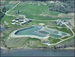
Town Forest In 1996 Thomaston purchased 350 acres of land near Oyster River for a new wastewater treatment facility. About 100 acres of it are used for a state of the art lagoon and land application system. The rest of the land, much of it forested, adjoins the resource protected zone along the Oyster River. The Oyster River flows through a 6,000 acre watershed or rare peat bog, swamp and upland forest before emptying into the St. Georges River on Thomaston's western boundary. Much of the Oyster River Bog is protected by conservation easements. The Town Forest has been used for hunting and recreation for generations. Wild turkey, moose, deer, and other animals are found there. The Forest is overseen by the Thomaston Conservation Commission. A conservation easement has been placed on 100 acres of the total parcel. The Conservation Commission and the Pollution Control Department jointly have developed a system of trails within the Forest for public use. The Town Forest Section will connect eventually with other sections of the Georges Highland Path to form a hiking trail through much of the Georges River Watershed. Cooperating Landowner: Paul Thorndike
The Watershed The watershed of the St. Georges River, known locally as the "Georges River", is a varied and beautiful region of the heartland of midcoast Maine. It covers 225 miles of wooded hills, blueberry barrens, family farms, small towns and rural villages. Fed by streams, ponds and wetlands, the river winds through the lowland 38 miles from its source near Frye Mountain to Port Clyde, where it empties into Muscongus Bay.
The
Georges River Land Trust The Land Trust is a nonprofit organization organized in 1987. Its mission is to preserve the scenic and historic integrity of the St. Georges River and its surrounding area; to maintain and improve its access for public enjoyment; to protect wildlife habitat; and to inform the people about the watershed and the importance of conserving it. Policy is determined by a volunteer board, and working operations are carried out by a small professional staff and members.
Membership Membership is open to all interested in protecting the St. Georges River and its watershed. For more information call the Georges River Land Trust at 594-5166 or write: Georges River Land Trust, 328 Main St., Studio 206, Rockland, Maine 04841. |
|